SOUTHERN CALIFORNIA, CA — A dangerous combination of triple-digit heat and gusty winds has prompted the National Weather Service to issue a Red Flag Warning for parts of Southern California, raising concerns about rapidly spreading wildfires.
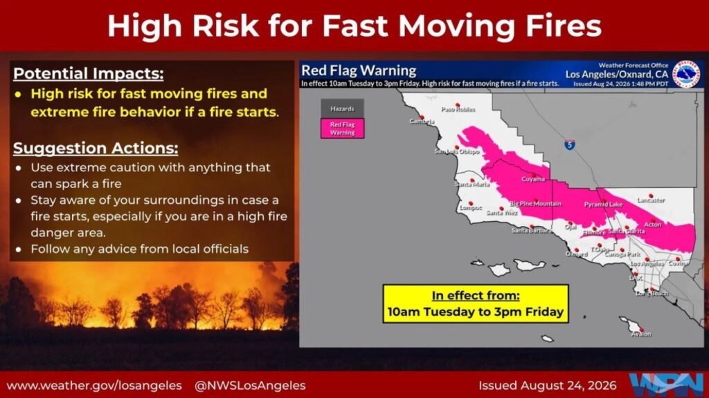
The warning is scheduled to take effect at 10 a.m. Tuesday and remain in effect until 3 p.m. Friday.
The advisory covers several areas where hot, dry and windy conditions could create dangerous fire-weather conditions, including the Cuyama Valley, San Luis Obispo County Mountains, Santa Barbara County Interior Mountains, North and South Ventura County Mountains, I-5 Freeway corridor, West San Gabriel Mountains and Highway 14 corridor.
Forecasters are warning that the combination of weather and fuel conditions could allow fires to grow rapidly if an ignition occurs.
Triple-Digit Heat and Gusty Winds Raise Fire Risk
Meteorologists expect temperatures to climb into the 98-to-106-degree range across lower mountain and foothill communities during the warning period.
The heat will be accompanied by winds generally ranging from 15 to 25 mph, with stronger gusts reaching around 35 mph at times.
Those winds could make an already dangerous fire situation significantly worse by helping flames spread quickly across dry vegetation.
The National Weather Service warned that conditions could support large plume-dominated fires, which can produce extreme fire behavior and spread rapidly.
“There is a significant risk of large plume dominated fires with rapid fire spread and extreme fire behavior,” the NWS wrote in its advisory.
The agency also pointed to a history of major fires occurring around this time of year under similar weather and fuel conditions, including the Bridge, Bobcat and Station fires.
Strongest Winds Expected Along I-5 and Highway 14
While gusty winds are expected across the affected areas, forecasters say the strongest winds will likely develop along the 5 Freeway and Highway 14 corridors.
Winds in those locations could become particularly strong between Thursday night and Friday morning, when gusts are forecast to reach approximately 40 mph.
That timing could create an especially dangerous period for wildfire activity, as strong winds can quickly push flames into new areas and make fires more difficult for firefighters to contain.
The combination of extreme heat and strong winds also means that a small ignition could become a serious wildfire before emergency crews have an opportunity to fully respond.
Officials Urge Extreme Caution Around Sparks
With fire danger elevated across the region, National Weather Service officials are urging residents and visitors to take extreme caution with anything that could spark a fire.
Activities involving flames, machinery, vehicles or other potential ignition sources can become particularly hazardous during Red Flag conditions.
Residents in affected areas are encouraged to stay alert to weather and fire updates throughout the warning period.
The most dangerous conditions are expected to continue through Friday, with the combination of very high temperatures, dry fuels and gusty winds creating an environment where fires could spread quickly.
For Southern California communities already familiar with the threat of destructive wildfires, forecasters say the upcoming weather pattern deserves serious attention.
Are you in an area affected by the Red Flag Warning? Share how you’re preparing for the dangerous heat and elevated fire risk in the comments.