
SOUTH FLORIDA — Residents are being urged to keep the rain gear nearby as a developing tropical weather pattern could bring more widespread showers, thunderstorms and heavy downpours to the region later this week.
The increased rain chances are tied in part to moisture associated with the remnants of what was once Tropical Storm Dolly. As that moisture moves generally toward the region, forecasters expect conditions across South Florida to become increasingly unsettled.
For now, there is no confirmed hurricane headed directly for Florida in the forecast described. Instead, the immediate concern is the potential for additional rainfall and localized flooding as tropical moisture increases.
The wet pattern comes as the beginning of September gets underway, with rain chances expected to rise from the middle to the latter part of the week.
Gulf System Brings Heavy Rain and Flooding Risk
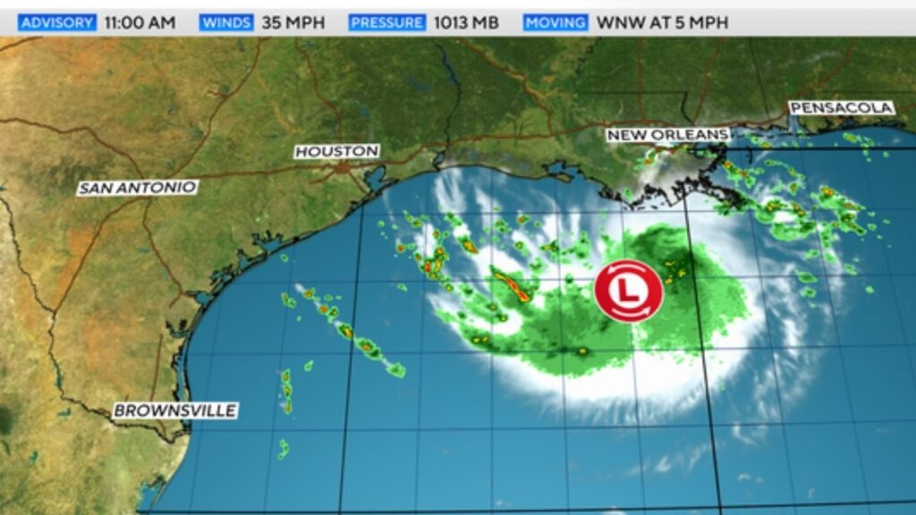
Meanwhile, a separate system in the northern Gulf of Mexico has been closely watched by the National Hurricane Center.
The system was classified as Potential Tropical Cyclone Five, with tropical storm warnings issued for portions of the Upper Texas Gulf Coast and Louisiana.
As of the 11 a.m. advisory, the system had maximum sustained winds of 35 mph, a central pressure of 1013 millibars and was moving west-northwest at about 5 mph.
A Hurricane Hunter aircraft and overnight satellite observations indicated that the system had become organized enough for forecasters to begin issuing advisories ahead of expected development.
A Tropical Storm Warning was in effect from Port Bolivar, Texas, to the Vermilion/Cameron Parish line in Louisiana.
System Could Strengthen Before Landfall
Forecasters expected some strengthening before the system reached the coast Tuesday.
Warm Gulf waters and weak wind shear were providing conditions that could allow the system to become stronger before landfall. Sea surface temperatures along its path were reported to be above 86 degrees.
Because the system is relatively small, forecasters warned that it could intensify quickly, meaning additional strengthening beyond the current forecast could not be ruled out.
Heavy rainfall and flash flooding were expected from the upper Texas coast through east-central Texas and into southwestern Louisiana from Tuesday into Wednesday.
Some areas around Houston could receive 4 to 7 inches of rain, with isolated higher amounts possible closer to the coast. Minor to moderate coastal flooding was also possible.
Gulf System Expected to Weaken Quickly
Despite the potential for short-term strengthening, the system is expected to weaken after moving inland.
Forecasts called for winds to fall to around 30 mph, with the system becoming post-tropical by Tuesday night into Wednesday. Dissipation was expected by early Thursday.
If the system strengthens into a tropical storm, it would receive the name Edouard.
That system is separate from another disorganized surface trough being monitored farther east, which currently has only a 10% chance of redevelopment.
Other Tropical Moisture Could Affect the Caribbean
The National Hurricane Center said any redevelopment of that eastern system would likely be slow because of unfavorable upper-level winds.
However, regardless of whether it develops into a tropical cyclone, the system could still produce heavy rain and gusty winds across portions of the Leeward Islands, Virgin Islands, Puerto Rico, Hispaniola and the Bahamas during the next several days.
That moisture is part of the broader tropical pattern that could eventually contribute to higher rainfall chances farther west.
South Florida Rain Chances Rise Later This Week
For South Florida, the main issue to watch is increasing moisture and rainfall, rather than a confirmed hurricane threat.
As moisture associated with the tropical system moves in the general direction of the region, rain chances are expected to increase later this week.
That could mean more frequent showers and thunderstorms, along with periods of heavy downpours and localized flooding, particularly in areas that receive repeated rainfall.
Residents should continue monitoring updated forecasts as the tropical pattern evolves. Conditions can change quickly, especially when multiple tropical disturbances are active.
Do you think South Florida is in for a particularly wet start to September? Share your thoughts and weather plans in the comments below.









One thought on “Tropical Storm Dolly Remnants Head Toward Florida Region as Rain Chances Rise and Flooding Threat Grows”