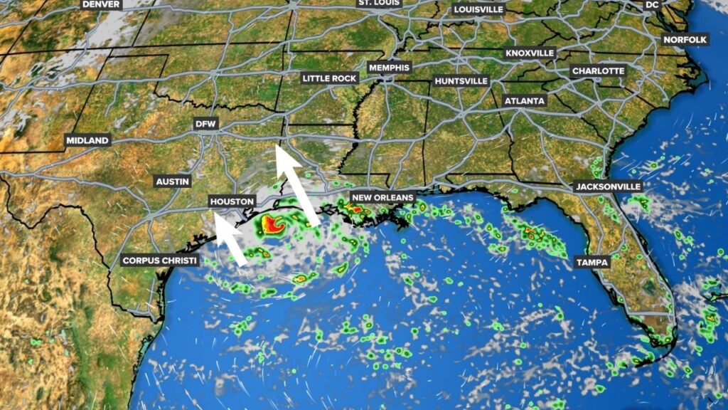
WASHINGTON — A developing tropical system in the northern Gulf is quickly becoming the main weather concern along the Gulf Coast, as Invest 97L continues to organize and could become the Atlantic season’s next named storm, Tropical Storm Edouard.
The system was located about 125 miles south of southeastern Louisiana and has shown increasing shower and thunderstorm activity. Forecasters say additional development is possible as the low slowly moves west-northwestward toward the coast.
The National Hurricane Center has raised the system’s chance of development to 70% over the next 48 hours and over the next seven days.
If the system reaches tropical-storm strength, it would receive the name Edouard. Forecasters are still trying to determine exactly how strong the system could become and where it will make landfall.
Texas and Louisiana Face the Greatest Concern
The current forecast places the greatest concern along portions of southwestern Louisiana and the Upper Texas coast.
The system is expected to move slowly west-northwestward and could reach the coast by Tuesday or Tuesday night. Because the system is still developing, its exact track and intensity remain uncertain.
That uncertainty means residents should not focus only on whether the system officially becomes a named storm.
Even without becoming Edouard, the disturbance can still produce tropical downpours and locally heavy rainfall as moisture spreads toward the coast.
Forecasters are also watching the possibility of tropical-storm watches or warnings being issued for portions of the region as the system gets closer to land.
Heavy Rain Could Become the Biggest Impact
For residents across southeast Texas and southwestern Louisiana, rainfall may be the biggest concern from Invest 97L.
If the system strengthens before moving inland, periods of heavy rain could develop along and near the projected path. Some areas could see locally intense rainfall, particularly where rain bands repeatedly move across the same locations.
That could create a low-end flooding threat, especially in areas that receive the heaviest downpours.
Recent forecasts indicate that even if the storm does not become particularly strong, its tropical moisture could still bring a noticeable increase in rainfall. Houston-area forecasters are also watching for several rounds of rain during the week.
Because the disturbance is expected to move relatively slowly, rainfall could become more important than wind impacts in some locations.
System’s Strength and Landfall Remain Uncertain
One of the biggest questions surrounding Invest 97L is how much time it has to strengthen before reaching land.
The system is already becoming better organized, but forecasters are still evaluating its circulation and thunderstorm activity. An Air Force Reserve reconnaissance aircraft was scheduled to investigate the system to gather additional information.
That information should help forecasters better understand the system’s structure and improve projections for its intensity and track.
At this point, residents should avoid assuming that a weaker forecast automatically means there is no threat. Tropical systems can produce significant rainfall even when winds remain relatively modest.
Dolly’s Remnants Add Another Tropical Concern
Invest 97L is not the only system being watched.
The remnants of former Tropical Storm Dolly are also moving westward and could bring additional tropical moisture toward Florida later in the week.
The system remains disorganized, and near-term redevelopment is not considered especially likely. However, forecasters are watching how the remnants evolve as they move closer to the eastern Gulf.
If the system reorganizes, portions of Florida could experience periods of heavy rain and localized flooding, depending on where the strongest rain bands develop.
Gulf Coast Residents Should Watch Forecast Updates
For now, the most important message for residents from Louisiana through southeast Texas is to stay informed as Invest 97L develops.
The system could become Tropical Storm Edouard before reaching the coast, but even if it does not, heavy tropical rainfall remains possible.
Forecast confidence should improve as reconnaissance data and additional observations become available. Residents should continue checking official forecasts and their local weather teams for updates on rainfall, flooding, wind impacts and possible watches or warnings.
The Gulf system is expected to remain a key weather story through the middle of the week, while Dolly’s remnants provide another tropical feature to watch farther east.
Are you in Louisiana, Texas or Florida and preparing for the potential tropical weather? Share your thoughts and plans in the comments below.