
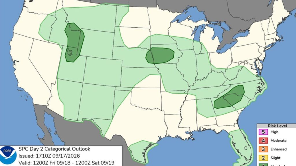
United States — A sprawling storm system is expected to bring thunderstorms, heavy rain and isolated severe weather across a large portion of the country this weekend, with the threat gradually shifting east from the Rockies toward the Northeast.
According to the Storm Prediction Center, severe weather is not expected to be widespread, but millions of people could experience thunderstorms as the system moves through. Some stronger storms could produce damaging wind gusts and large hail, while areas receiving repeated or particularly heavy rainfall could face localized flooding.
The weather pattern will not bring one single storm to every part of the country at the same time. Instead, several rounds of unsettled weather are expected to develop and move east during the coming days.
Rockies and Plains face early storm threat
The first part of the storm pattern will focus on the Great Basin, Rockies and northern Plains.
Scattered thunderstorms are expected across Idaho and Utah on Thursday and Friday, with some storms potentially becoming strong enough to produce large hail and damaging wind gusts.
As the system progresses, storms will spread from Colorado into Nebraska, Kansas and parts of Oklahoma through Saturday. While widespread severe weather is not anticipated, isolated severe wind gusts and hail remain possible.
The timing and intensity of individual storms could vary considerably by location, meaning some communities may see only routine thunderstorms while others experience stronger cells.
Midwest and Mississippi Valley see heavier rain
By Friday, thunderstorms are expected to develop across portions of Nebraska and Iowa before gradually spreading toward the Mississippi Valley.
As the storm activity shifts east, heavy rainfall becomes a bigger concern.
The Ohio Valley could see a more widespread round of thunderstorms Sunday as a low-pressure system and cold front move east. Some locations could experience heavy downpours capable of producing localized flash flooding, particularly where rainfall accumulates quickly.
The combination of thunderstorms and a slow-moving weather pattern could make rainfall impacts more significant in some areas even where severe thunderstorms do not develop.
Northeast and Mid-Atlantic storm threat arrives Sunday
The unsettled weather is expected to reach the Northeast and Mid-Atlantic on Sunday and Monday.
Showers and thunderstorms will spread across the region as the associated cold front moves east. Heavy rain and localized flash flooding will be possible, especially in areas where storms repeatedly track over the same locations.
For the weekend overall, the primary trend will be a gradual eastward shift in the storm threat.
Thursday and Friday: Storms develop across the Great Basin, Rockies and northern Plains.
Saturday: Thunderstorms expand across the central and southern Plains, including parts of Texas, with isolated damaging winds and hail possible.
Sunday: The focus moves toward the Midwest, Mississippi Valley and Northeast, with heavy rain and thunderstorms raising flooding concerns.
Monday: The cold front continues moving south and east, carrying showers and thunderstorms farther into the eastern United States.
Texas could see more storms next week
The unsettled weather will not necessarily end when the weekend system moves east.
Nearly 1,000-Pound Ocean Giant Found Dead on Cape Cod Beach as Seasonal Migration Begins
Texas could face another round of thunderstorms beginning Tuesday, as a trough moving into the West helps draw monsoon moisture northward toward the Southern High Plains.
Thunderstorm activity is expected to increase across New Mexico and the Texas Panhandle, with additional chances for storms potentially continuing through the rest of next week.
Repeated rainfall could increase the risk of heavy rain and flash flooding, particularly in locations that are especially vulnerable to rapid runoff. Burn scars, slot canyons, dry washes and areas with recently saturated soil can become dangerous when intense rainfall develops.
Why the storm threat is shifting east
The weather pattern is being driven by multiple upper-level features.
According to the Storm Prediction Center, a trough moving across the northern tier of the country will help push a cold front south and east through the Plains, Midwest and Northeast.
Meanwhile, another upper-level trough moving into the West will help pull monsoon moisture northward into the Southern High Plains next week.
That setup means the United States is likely to experience several rounds of unsettled weather rather than one continuous storm system.
Is severe weather expected in your area this weekend? Share your location and weather concerns in the comments





One thought on “Millions Could Face Storms This Weekend — Check the Day Weather Changes in Your Region”