Los Angeles, California — Hurricane Polo has become one of the strongest Pacific hurricanes in decades, and although the powerful storm is not expected to make landfall in California, Southern California’s coastline could still face dangerous conditions from large waves, strong surf and elevated tides in the days ahead.
Polo reached Category 5 strength Tuesday, packing maximum sustained winds of 180 mph before weakening to a Category 4 hurricane Wednesday morning. The storm was still producing winds of around 150 mph as it moved slowly north roughly 165 miles south of Zihuatanejo, Mexico.
Kristen L. Corbosiero, a professor of atmospheric and environmental sciences at the University at Albany, described Polo’s strength to The Associated Press as remarkable.
“This is one of the strongest storms ever in the (Pacific) Basin,”
Although Polo is expected to remain offshore and eventually turn northwest, its powerful circulation could still affect Southern California’s coastline.
California’s Biggest Concern Is Powerful Surf
For Southern California, dangerous waves rather than direct hurricane winds or heavy rain are expected to be the primary concern.
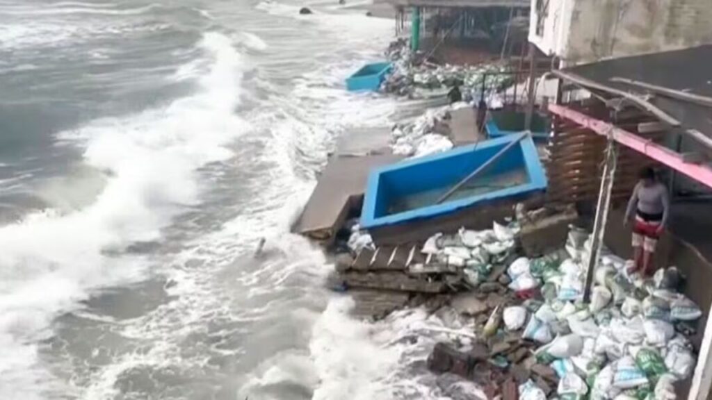
The region has already endured repeated periods of powerful southerly swell this summer. Those waves have contributed to beach erosion, damaged waterfront infrastructure and forced several coastal communities to take emergency measures.
Now, another round of elevated surf could arrive just as high tides affect the region early next week, potentially increasing the risk of coastal flooding and additional erosion.
Bryan Lewis, a meteorologist with the National Weather Service in Oxnard, told the Los Angeles Times that elevated surf and high tides could overlap Monday and Tuesday.
That combination could become particularly concerning for beaches that have already lost substantial amounts of sand.
Long Beach Still Recovering From Earlier Damage
Long Beach is among the communities still dealing with the effects of powerful waves that struck during Labor Day weekend.
Residents along the Alamitos Peninsula have seen sections of the beach disappear, while waves also damaged portions of the waterfront boardwalk.
Longtime resident Mike Grimaldi described the dramatic change:
“There used to be 200 feet of beach of sand between here and the waves. All gone,”
Craig VanDuren, who has lived in the area for 29 years, said the recent damage was among the worst he had experienced.
“I’ve been here 29 years, and this is probably the worst one we’ve had,”
Residents have been constructing sand berms around vulnerable areas as officials prepare for the possibility of another period of damaging surf.
Other California Beaches Remain Vulnerable
The potential impacts extend beyond Long Beach.
Communities including Laguna Beach, Dana Point and Carlsbad have already experienced significant beach erosion and sand loss from previous storms.
Another prolonged period of elevated surf could worsen those conditions, especially if the largest waves arrive during high tide.
The National Weather Service is forecasting elevated surf and strong rip currents at Southern California beaches beginning this weekend and continuing into next week as multiple southerly swells move toward the coast.
That could create dangerous conditions for swimmers, surfers and anyone near exposed beaches.
Polo Could Also Send Moisture Toward California
Rain is another possible impact, although it is not currently expected to be the main concern.
Polo could potentially pull tropical moisture toward Southern California depending on the storm’s track and atmospheric setup. However, the immediate rainfall threat remains limited.
Lewis said Tuesday that there was only a 5% chance of rain in Los Angeles County.
The more immediate concern is therefore the combination of large waves, strong surf and high tides rather than widespread rainfall.
Polo Reached Extraordinary Strength
Polo’s rapid intensification has made it one of the most notable Pacific hurricanes in recent years. The storm reached 180-mph winds Tuesday, briefly becoming a Category 5 hurricane before weakening to Category 4 strength.
Its peak intensity puts it among a relatively small group of extremely powerful eastern Pacific hurricanes. Hurricane Patricia, which reached 215 mph in 2015, remains one of the strongest storms ever recorded in the basin.
Polo became the third Category 5 hurricane of the eastern Pacific season, following Genevieve and Lowell.
Nor’easter Threatens the East Coast With Flooding, 50-MPH Winds and Heavy Rain This Weekend
Forecasters expected Polo to remain a major hurricane as it turns northwest and eventually west-northwest.
While a direct Mexican landfall was not expected, tropical-storm conditions were forecast along portions of the country’s southwestern coast. Parts of Guerrero and Michoacán could receive 3 to 6 inches of rain, raising concerns about flash flooding and mudslides.
El Niño Could Shape California’s Winter
Polo’s rapid strengthening is also occurring as California prepares for what forecasters describe as a potentially exceptionally strong El Niño.
The climate pattern involves unusually warm waters across the central and eastern tropical Pacific and can contribute to favorable conditions for powerful eastern Pacific hurricanes.
Philip Klotzbach, an atmospheric scientist at Colorado State University, told the AP that warm ocean temperatures and wind patterns associated with El Niño helped create conditions favorable for Polo’s rapid strengthening.
“There are all the ingredients that hurricanes need to get really strong really fast,”
California officials are also preparing for the potential winter consequences.
Gov. Gavin Newsom declared a statewide emergency Monday, citing concerns about severe storms, coastal flooding and other weather-related hazards.
For Southern California residents, however, the first concern may arrive much sooner.
Are you watching Hurricane Polo’s potential impact on Southern California? If you live near the coast, share what conditions you’re seeing in your area in the comments below.