
Hawaii—The Pacific is becoming increasingly active as Hurricane Lowell has rapidly intensified into a monster Category 5 storm, joining several other tropical systems that are keeping forecasters on alert.
Lowell strengthened into a hurricane early Tuesday before rapidly intensifying overnight. By late Tuesday, it had become a major hurricane, and the National Hurricane Center upgraded Lowell to Category 5 status Wednesday evening.
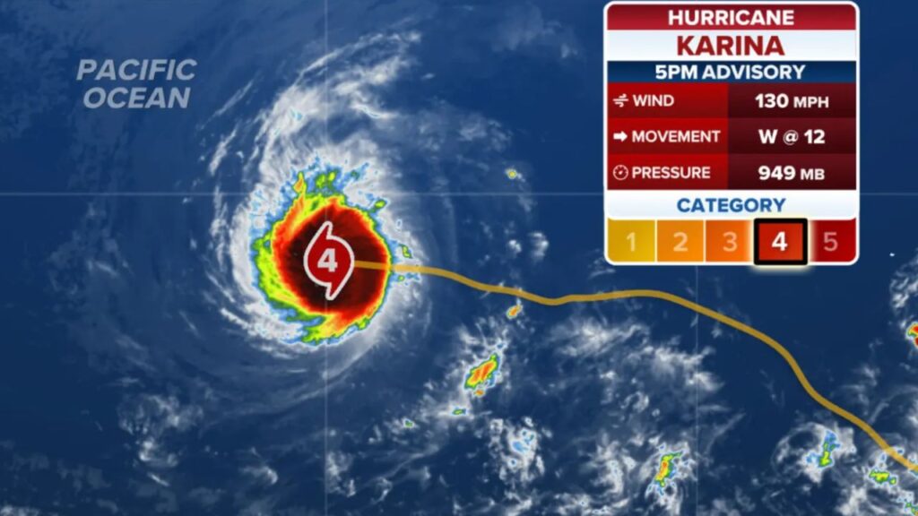
The powerful storm is now one of the main features across the Pacific basin, alongside Category 4 Hurricane Karina.
“There are no immediate threats, but that could certainly change,” Forecasters said.
For now, Lowell remains over open waters. However, its long-range track is drawing attention because of the possibility that its path could eventually bring it closer to Hawaii.
Hurricane Karina Adds Uncertainty to Lowell’s Forecast
While Lowell has been strengthening, Hurricane Karina is also a powerful Category 4 storm moving generally westward over the eastern Pacific.
The interaction between the two hurricanes could become one of the biggest forecasting challenges in the coming days.
Karina is currently being steered westward by high pressure to its north. If that ridge strengthens, Karina could potentially take a slightly more southerly path, which could eventually bring it closer to Hawaii.
Lowell, meanwhile, is expected to continue generally westward for the next couple of days under the influence of high pressure to its north.
Beyond that period, however, the forecast becomes significantly more complicated. Computer forecast models are showing increasing disagreement over when and how sharply Lowell could turn west-northwest.
Hawaii Watching the Storms Closely
The future movement of Lowell could be influenced by Karina’s position and strength.
If the two storms come relatively close together, their interaction could disrupt Lowell’s environment and potentially limit its development. If they remain farther apart, Lowell could have more opportunity to take advantage of favorable atmospheric conditions.
At this point, Lowell is projected to track south of Hawaii before potentially making a larger turn toward the north. However, forecasters caution that there are too many variables this far out to provide a highly confident long-range forecast.
That uncertainty is particularly important for Hawaii, where residents and officials are watching the evolving Pacific pattern even though there is no immediate threat at this time.
Lowell has also reached a notable milestone. According to NOAA, it is the first Category 5 storm in the Central Pacific basin since Hurricane Walaka in October 2018.
Tropical Storm Marie Churns Near Mexico
The Pacific’s activity is not limited to Lowell and Karina.
Tropical Storm Marie continues to spin off the southwest coast of Mexico, where environmental conditions could allow the storm to strengthen further.
Forecasters are also watching whether moisture associated with Marie could eventually move northward toward California early next week.
As Marie tracks north through the end of the week, it could transport additional tropical moisture into the region.
That moisture is already contributing to concerns about heavy rain and flooding potential, with a Level 2 out of 4 flash flood risk expected across parts of southern Arizona on Friday, including the Phoenix and Tucson areas.
Another Tropical System Being Watched
Forecasters are also monitoring another developing area near the southwestern coast of Mexico, close to the region where Marie is currently moving.
The National Hurricane Center said an area of low pressure could form over the weekend, with gradual development possible as early as next week.
At the moment, the system has a 20% chance of development over the next seven days and a near-zero chance of developing during the next two days.
That means the immediate focus remains on Lowell, Karina and Marie, but the Pacific could become even more crowded if the newer disturbance organizes.
Pacific Activity Continues to Build
The unusually busy tropical pattern is being fueled in part by an ongoing El Niño pattern, which is contributing to increased activity across the Pacific.
For residents in Hawaii and other potentially affected areas, the key message is to avoid focusing too heavily on any single long-range forecast. Storm tracks can change substantially as weather systems interact and atmospheric conditions evolve.
For now, Lowell remains the biggest concern because of its Category 5 strength, while Karina, Marie and the developing disturbance add complexity to an already active Pacific basin.
Are you keeping an eye on Hurricane Lowell and the other Pacific storms? Share your thoughts and stay tuned for the latest updates.









2 thoughts on “Monster Hurricane Lowell Reaches Category 5 Strength as Another Major Hurricane and Tropical Storms Crowd the Pacific”