
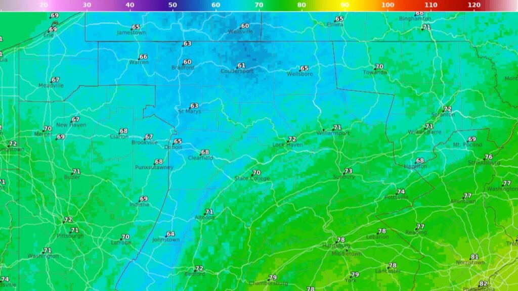
PENNSYLVANIA — A cooler start is giving residents across the state a brief break from hotter summer temperatures, but the relief is not expected to last for long.
Tuesday’s forecast calls for temperatures that are mostly below the 80-degree mark, with only the warmest parts of Pennsylvania reaching the low 80s, according to the National Weather Service.
Southeastern Pennsylvania will be the warmest part of the state. Philadelphia is expected to reach around 82 degrees, while Norristown could reach 81 and York and Lancaster are forecast near 80.
Farther west and north, temperatures will be noticeably cooler.
Harrisburg, Chambersburg and Allentown are expected to remain in the mid- to upper 70s, while Pittsburgh may only reach about 71 degrees. State College and the Pocono region could top out near 69 degrees, with even cooler readings possible near the northern border with New York.
For anyone hoping this is an early sign of fall, however, the forecast suggests otherwise.
Temperatures Start Climbing Wednesday
The cooler conditions won’t stick around for long.
By Wednesday, nearly the entire state is expected to climb back above 70 degrees, with only higher elevations such as the Laurel Highlands potentially remaining cooler.
Temperatures will continue rising gradually, with southeastern Pennsylvania reaching the mid-80s by Wednesday afternoon.
The Harrisburg area is expected to see mostly sunny skies and a high near 84 degrees Wednesday. Winds will be calm before becoming southerly at around 5 mph during the afternoon.
Wednesday night could bring the first signs of the week’s wetter weather. The National Weather Service is forecasting a chance of showers during the early morning hours, followed by a chance of showers and thunderstorms after daybreak.
The chance of precipitation is around 40%, with generally light rainfall expected outside of thunderstorms.
Thursday Could Bring the Week’s Wettest Weather
Thursday is shaping up to be the most unsettled day of the week.
A 70% chance of precipitation is forecast for the Harrisburg area, with showers and thunderstorms possible at several points throughout the day.
The day could begin with showers before transitioning into additional showers and thunderstorms later in the afternoon. Despite the rain, temperatures are still expected to reach around 85 degrees.
Thursday night will remain unsettled, with showers and possibly a thunderstorm continuing into the evening. The chance of precipitation is expected to remain around 60%.
The rain could help prevent temperatures from climbing toward the 90-degree mark, particularly in parts of southern and eastern Pennsylvania.
Pennsylvania Avoids 90-Degree Heat This Week
Despite temperatures rising through the middle of the week, the forecast does not currently show 90-degree temperatures anywhere in Pennsylvania.
After Thursday’s rain, conditions should become much calmer.
Friday is expected to be mostly sunny with a high near 84 degrees, followed by a partly cloudy night with temperatures falling to around 64.
Saturday will remain mostly sunny with a high near 83 degrees, while Sunday could reach around 85 degrees under mostly sunny skies.
Most of the state should therefore experience a relatively comfortable stretch compared with periods of more intense summer heat.
So, How Long Will the Cooler Weather Last?
The short answer is: not very long.
Tuesday provides the coolest conditions of the week, but temperatures begin recovering Wednesday before reaching the mid-80s in many areas later in the week.
Rain and thunderstorms could interrupt the warming trend Thursday, but the weekend forecast returns to mostly sunny skies with temperatures in the low to mid-80s.
So while Pennsylvania may feel a little more like fall at the start of the week, autumn is not arriving just yet.
Are you enjoying Pennsylvania’s cooler temperatures, or are you ready for summer heat to return? Share your thoughts in the comments.




One thought on “Cooler Air Brings Relief to Pennsylvania, But Midweek Warmth and Thursday Storms Are Ahead”