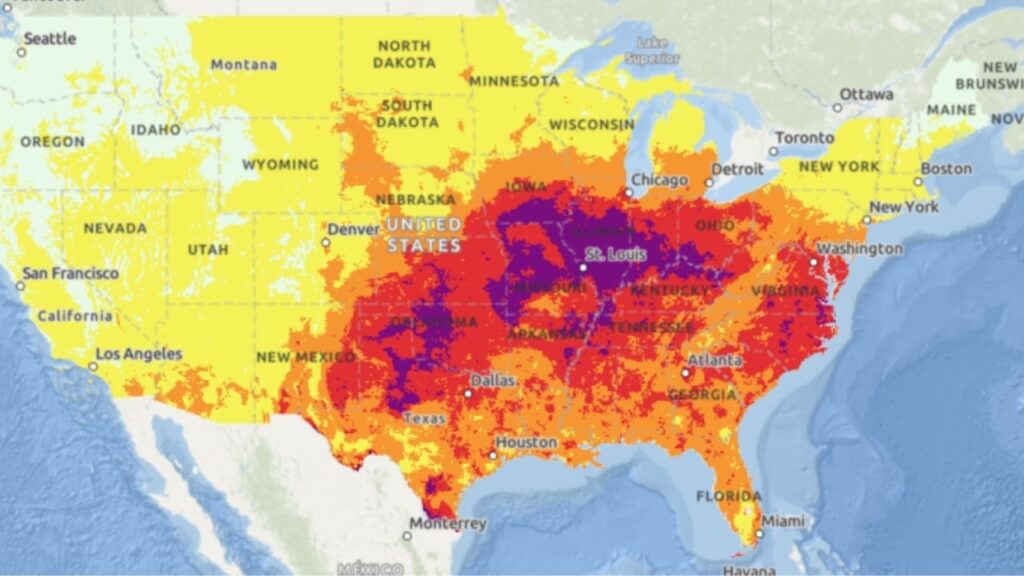
CHICAGO, Ill. — September is typically a time when summer begins giving way to cooler fall conditions, but residents across the Chicago area could get a very different taste of weather during the first week of the month.
A “huge” dome of hot air is expected to move into the region, bringing a combination of high humidity, warmer temperatures and periodic chances for rain and thunderstorms.
The National Weather Service warned that the upcoming pattern could make conditions feel much more like mid-July than early September.
“Hot and humid conditions will return next week with daily heat indices at or above 90F,” the NWS said in a post on X.
The uncomfortable conditions are expected to become especially noticeable during the middle of the week, with Tuesday, Wednesday and Thursday currently standing out as the most humid days.
Some Areas Could Feel Like 95 Degrees
The actual air temperature is only part of the story.
High humidity will make the heat feel considerably stronger, pushing heat index values into the 90s across much of the region.
According to the NWS, Joliet, Kankakee, Ottawa, Paxton and Pontiac could experience heat indices of 95 degrees or higher during the middle of the week.
That means residents could experience conditions that feel substantially hotter than the thermometer suggests.
Meteorologists say the Chicago area is positioned along the northern edge of the developing heat pattern.
“We’re on the northern edge,” Sack said.
That position could create some differences across the region, with temperatures and humidity potentially varying depending on exactly where the boundary of the hot air settles.
Still, the broader message for residents is clear: September could begin with a significant return of summer-like heat.
Humidity Will Build Starting Sunday
The transition into the hotter pattern is expected to begin Sunday.
Sack said dew points will rise into the 70s, a sign that moisture will increase significantly in the atmosphere.
Higher dew points generally mean the air feels more humid, sticky and uncomfortable, especially when temperatures are also climbing.
The combination of heat and moisture is what will drive the elevated heat index readings expected throughout the week.
Residents who spend time outdoors could notice the difference quickly, particularly during the afternoon when temperatures are at their highest.
The weather pattern could also make outdoor activities more challenging, as the combination of heat and humidity can leave people feeling much warmer than the actual air temperature.
Rain and Storm Chances Arrive With the Heat
The heat dome won’t bring sunshine alone.
Forecasters are also watching multiple opportunities for rain and thunderstorms as the pattern develops.
Rain chances are expected to begin Sunday night into Monday and continue on and off through at least Thursday.
That means the Chicago area could experience a mix of hot, humid periods followed by passing showers or thunderstorms.
The exact timing and location of the storms can still change as the forecast gets closer, but residents should be prepared for weather conditions to shift throughout the week.
The combination of heat, humidity and storms could also make conditions feel unsettled across parts of the region.
Cooler Weather Arrives Before the Heat
Before the heat returns, Chicago-area residents are expected to get a brief break from summerlike conditions.
Friday is expected to be comfortable, with dry weather and partly cloudy skies.
Saturday could remain relatively pleasant, although forecasters are calling for a chance of light rain at times.
That short period of more comfortable weather will be followed by the gradual buildup of heat and humidity beginning Sunday.
By the middle of the following week, the region could once again feel like the heart of summer.
With heat indices potentially reaching 95 degrees or higher in parts of the area, residents should keep an eye on updated forecasts as the first week of September approaches.
The forecast remains subject to change, particularly regarding the timing of rain and storms, but meteorologists are already highlighting the unusual return of dangerously summer-like heat for early September.
Are you ready for summer-like heat to return in September, or are you already looking forward to cooler fall weather? Share your thoughts in the comments.