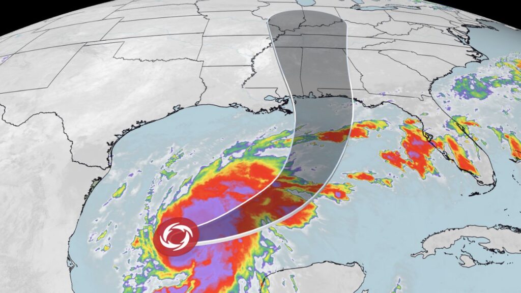
Ocean Springs, Mississippi — Tropical Storm Isaias is rapidly intensifying over the Gulf of Mexico and could become the first Atlantic hurricane of the 2026 season before reaching the U.S. Gulf Coast this weekend.
The storm, which developed from Tropical Depression Nine on Wednesday, was moving toward the northern Gulf Coast as forecasters warned of dangerous winds, significant storm surge and life-threatening flooding.
Isaias is the Atlantic basin’s ninth named storm of the season, forming with less than two months remaining before the 2026 hurricane season officially ends on Nov. 30.
Isaias Could Become a Hurricane Before Landfall
The National Hurricane Center said Isaias was “quickly intensifying” as it moved across the Gulf.
The storm was expected to pass north of Mexico’s Yucatan Peninsula Thursday before approaching the northern Gulf Coast late Friday or early Saturday.
As of Wednesday evening, Isaias had maximum sustained winds of 70 mph, just below the 74-mph threshold required for hurricane status.
Tropical-storm-force winds were extending outward as far as 60 miles from the storm’s center.
Forecasters expected Isaias to reach hurricane strength by Thursday morning, potentially making it the first Atlantic hurricane of the 2026 season.
Hurricane and Storm Surge Warnings Cover Gulf Coast
A hurricane warning was issued for a section of the northern Gulf Coast stretching from Ocean Springs, Mississippi, to the Florida Bay and Gulf county line.
Tropical storm warnings covered areas from the Louisiana Jefferson/Plaquemines Parish line to Ocean Springs and from the Florida Bay/Gulf county line to the Aucilla River.
A storm surge warning was also issued from the mouth of the Mississippi River to Yankeetown, Florida.
Forecasters warned that the roughly 300-mile stretch between Ocean Springs and Indian Pass, Florida, could see storm surge of up to 7 feet above ground level at high tide.
Such a surge could produce major coastal flooding, particularly in low-lying communities and areas exposed to Gulf waters.
Heavy Rain Could Cause Widespread Flooding
Wind and storm surge are not the only concerns.
Isaias is expected to produce moderate to heavy rainfall across the Gulf Coast and Southeast from this weekend into early next week.
The central Gulf Coast, from southeastern Louisiana through the Florida Panhandle, could receive 3 to 7 inches of rain, with isolated totals reaching as high as 10 inches.
A much broader area could also see significant rainfall.
Parts of the Southeast, extending northward into the Tennessee Valley and the Carolinas, could receive between 1 and 5 inches of rain. Forecasters warned that Isaias could trigger urban flooding and isolated river flooding as the storm moves inland.
Some longer-range forecast models also indicate that moisture from the system could eventually reach the Ohio Valley and Northeast by the middle of next week.
Officials Urge Residents to Prepare Now
The National Hurricane Center warned Thursday of an “increasing risk of dangerous wind and storm surge impacts” along portions of the northern Gulf Coast.
Residents in Louisiana, Alabama, Mississippi and northern Florida were urged to closely monitor forecast updates and make sure their hurricane plans are ready.
The warning comes as the storm continues strengthening over warm Gulf waters, leaving communities with limited time to prepare before potential impacts begin.
Florida and Alabama Declare States of Emergency
Florida Gov. Ron DeSantis moved ahead of the storm by declaring a state of emergency for 25 Florida counties.
The order was designed to give communities additional time and resources to prepare for potentially severe conditions across the Panhandle and Big Bend region.
Texas Mom Issues Halloween Warning After Her Baby Nearly Dies From Salmonella Linked to Pumpkins
DeSantis said the order “ensures communities have the time and resources necessary to prepare for potential severe weather impacts to the Panhandle and Big Bend region of Florida.”
Alabama Gov. Kay Ivey also issued a state of emergency covering 40 counties. Ivey said the declaration would allow Alabama officials “to take any needed steps ahead of landfall.”
Isaias Adds to a Late-Season Atlantic Threat
Isaias is developing relatively late in the 2026 hurricane season, but the storm’s name also carries some historical significance.
The Atlantic’s “I”-named storms have historically been among the names most frequently retired because of the destructive hurricanes that have carried them.
Notable retired I-names include Ian, Ida, Irma and Irene.
Isaias itself replaced the name Ike after Ike was retired in 2008. Atlantic storm names rotate through a six-year cycle unless a particularly deadly or costly storm leads officials to retire a name.
For Gulf Coast residents, however, the immediate concern is not the history behind the name but the storm approaching their communities.
With Isaias potentially reaching hurricane strength before landfall, residents along the northern Gulf Coast should continue monitoring official forecasts and preparing for dangerous wind, storm surge and flooding. Are you in the projected path of Isaias? Share your location and storm preparations in the comments.