Hilo, Hawaii — Hurricane Nolo has strengthened into a Category 1 hurricane as it approaches Hawaii, with forecasters warning that the storm could bring life-threatening flooding, damaging winds, dangerous surf and coastal flooding to the islands through the weekend.
Nolo is expected to become significantly stronger as it moves north toward the Big Island before eventually turning west. The storm could potentially reach major hurricane strength, Category 3 or higher, during the weekend, although its exact track remains uncertain.
Nolo Strengthens as Big Island Watches Closely
Nolo was located roughly 250 miles south of the Big Island and was moving north at about 5 mph as its outer bands began affecting Hawaii.
The storm’s arrival has already prompted hurricane and tropical storm alerts. A hurricane watch and tropical storm warning are in effect for the Big Island, while a tropical storm watch covers portions of Maui County.
Forecasters expect conditions to deteriorate through the night and into the weekend as Nolo approaches.
The latest forecast shows Nolo continuing north toward the Big Island before making a sharp turn west later Friday or Saturday. Recent forecast guidance has shifted the projected track farther south, keeping the Big Island outside the current cone of uncertainty.
That shift could keep some of the strongest conditions offshore, but forecasters caution that the storm can still wobble and that dangerous impacts can occur well outside the forecast cone.
Up to 35 Inches of Rain Could Fall
Flooding is expected to be one of the biggest threats from Nolo.
The storm’s outer bands can produce locally intense rainfall well before the center makes its closest approach. Forecast rainfall totals remain especially concerning across the Big Island and Maui.
Some mountain areas of the Big Island could receive as much as 35 inches of rain, while parts of Maui could see totals reaching around 15 inches. Other Hawaiian islands could receive up to 6 inches.
That amount of rain could overwhelm streams and drainage systems and trigger life-threatening flash flooding and mudslides, particularly across steep and mountainous terrain.
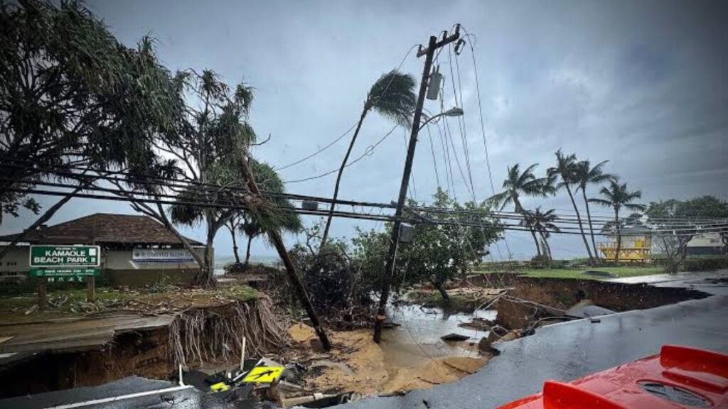
The danger is heightened because parts of the Big Island and Maui County were already hit by flooding, mudslides and strong winds from Hurricane Lala in August.
Damaging Winds Could Hit the Big Island
Rain will not be the only concern.
The southern portion of the Big Island has the greatest potential for tropical-storm-force winds capable of downing trees and causing power outages as Nolo passes nearby.
Depending on the storm’s final track, hurricane-force winds could also affect portions of the island.
Forecasters say wind gusts may become even stronger over mountain summits and on the downwind sides of slopes across the Hawaiian island chain.
That means communities outside the immediate path of Nolo’s center could still experience dangerous wind conditions.
Dangerous Surf and Coastal Flooding Expected
Nolo is also expected to generate increasingly large swells around Hawaii.
Dangerous surf and rip currents could develop as larger waves arrive ahead of the storm. Coastal areas of the Big Island could also face flooding as Nolo moves closer.
A 1- to 3-foot storm surge is possible around the Big Island, adding another hazard for low-lying coastal communities.
Nor’easter Threatens the East Coast With Flooding, 50-MPH Winds and Heavy Rain This Weekend
The combination of high surf, storm surge, heavy rain and strong winds could create dangerous conditions even if Nolo’s center remains offshore.
Nolo Could Become a Historic Storm for the Big Island
The storm’s potential significance goes beyond its immediate impacts.
According to NOAA’s hurricane database, only one other major hurricane has passed within 150 miles of the Big Island. That was Hurricane Dot in August 1959, which later struck Kauai after passing south of the Big Island.
If Nolo reaches major hurricane strength while making a similarly close approach, it could become the strongest hurricane to pass this close to the Big Island in roughly seven decades.
Hawaii Has Already Been Hit by Multiple Systems
Nolo would also become the fourth tropical system to affect Hawaii this season.
Hurricane Lala previously brought torrential rain and strong winds to the Big Island in August. Tropical Storm Moke followed, producing additional rainfall and flooding while the ground remained saturated.
Hurricane Lowell later reached Category 5 strength at its peak before weakening and passing near the western Hawaiian Islands, bringing strong winds, rain and large waves.
Nolo began as Tropical Depression Fifteen-E on Sept. 13, far southeast of Hawaii. The system weakened while moving west through strong wind shear, but it later encountered more favorable conditions and reorganized.
Now, the once-weakened system has returned as Hurricane Nolo, putting Hawaii on alert for another potentially dangerous round of tropical weather.
Are you watching Hurricane Nolo as it approaches Hawaii? Share your thoughts in the comments and let us know how the weather is changing in your area.